


SityTrail - TSN PERSO

UDGI54
Gebruiker
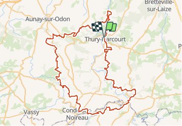

Lengte
100 km

Max. hoogte
357 m

Positief hoogteverschil
2521 m
Km-Effort
133 km

Min. hoogte
18 m

Negatief hoogteverschil
2518 m
Boucle
Ja
Datum van aanmaak :
2020-08-09 13:37:53.294
Laatste wijziging :
2020-08-09 13:37:53.294

Gratisgps-wandelapplicatie
 SityTrail
IGN / Geografische instituten
SityTrail Plus
De wereld gaat voor u open
Over ons
Tocht van 100 km beschikbaar op Normandië, Calvados, Le Hom. Deze tocht wordt voorgesteld door UDGI54.
Plaatsbepaling
Land:
France
Regio :
Normandië
Departement/Provincie :
Calvados
Gemeente :
Le Hom
Locatie:
Thury-Harcourt
Vertrek:(Dec)
Vertrek:(UTM)
684577 ; 5428966 (30U) N.
Opmerkingen